
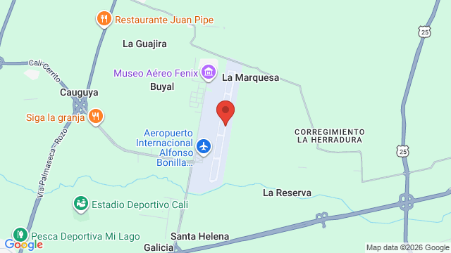
Alfonso Bonilla Aragón International Airport (IATA code: CLO, ICAO code: SKCL), formerly known as Palmaseca International Airport, is a civilian airport located in the municipality of Palmira, in Valle del Cauca Department, serving the city of Cali and its metropolitan area in Colombia. It is approximately 17 km (11 miles) northeast of downtown Cali and serves as the main airport for southwestern Colombia.
 Local time:
--:--
(UTC)
 ️
Temperature:
--
 Date:
—
️
Celsius:
—


Contact information
Flight departures and arrivals
Check real-time flight status at Cali - Alfonso Bonilla Aragón Airport (CLO) (CLO). Review schedules and possible delays before heading to the terminal or arranging your transportation.
Ground transportation
The airport is connected to Cali and Palmira by road, primarily via the Cali–Palmira highway and its access roads. Transportation options include taxis, intercity buses, private transfers and rental cars. For travel to central Cali, the main options are taxis, which provide direct transportation, and buses connecting the airport with Cali’s main bus terminal.
Taxis are a convenient option for direct transfers to hotels, private addresses and other destinations in Cali or Palmira, particularly for travelers carrying large amounts of luggage or arriving outside regular public transportation hours.
Passengers should confirm the fare before starting their journey and use authorized taxi services.
The journey takes approximately 30 minutes, depending on traffic conditions. Services use the route via Yumbo and provide a more economical alternative to taxis for passengers traveling between the airport and Cali’s bus terminal.
At the airport, shared transportation services can be found outside the arrivals areas on the ground floor. Passengers should confirm the departure point and schedule before traveling, particularly at night.
Travelers heading to other parts of Cali may need to arrange onward transportation from the city’s main bus terminal.
From international arrivals, exit and turn left. From domestic arrivals, exit and turn right to reach these rental counters.
Vehicle pickup and return arrangements depend on the rental company. Travelers are advised to confirm the pickup location, opening hours and return conditions before their trip.
 Airport facilities
Location
- Country Colombia
- Region Valle del Cauca Department
- Subregion Palmira Municipality
- Locality Palmira
- Elevation 964 m (3163 ft)
- Coordinates 3.543111, -76.381692
 Airlines and destinations
| Airline | Destinations |
|---|---|
 Avianca |
El Dorado (BOG) Miami (MIA) Fort Lauderdale - Hollywood (FLL) Medellín - José María Córdova (MDE) Aeropuerto de Cartagena (CTG) Aeropuerto de San Andrés (ADZ) Showing 6 of 10 · Show more destinations |
 JetSMART Chile |
El Dorado (BOG) Medellín - José María Córdova (MDE) Aeropuerto de Cartagena (CTG) Aeropuerto de San Andrés (ADZ) Aeropuerto de Santa Marta (SMR) Santiago - Arturo Merino Benítez (SCL) Showing 6 of 8 · Show more destinations |
 LATAM Airlines |
El Dorado (BOG) Medellín - José María Córdova (MDE) Aeropuerto de Cartagena (CTG) Aeropuerto de San Andrés (ADZ) |
 LATAM Airlines Colombia |
El Dorado (BOG) Medellín - José María Córdova (MDE) Aeropuerto de San Andrés (ADZ) |
 Clic Air |
El Dorado (BOG) Aeropuerto de Medellín - Olaya Herrera (EOH) |
 JetSMART Colombia |
Aeropuerto de Cartagena (CTG) Aeropuerto de San Andrés (ADZ) |
Showing 6 of 14
 Nearby airports
-
Aeropuerto de Buenaventura - Gerardo Tobar López (BUN) 46.1 mi (74.2 km)
- Aeropuerto de Armenia - El Edén (AXM) 75.8 mi (121.9 km)
-
Aeropuerto de Neiva - Benito Salas (NVA) 85.5 mi (137.6 km)
-
Aeropuerto de Pereira - Matecaña (PEI) 98.3 mi (158.1 km)
-
Aeropuerto de Ibagué - Perales (IBE) 105.3 mi (169.4 km)
-
Aeropuerto de Quibdó - El Caraño (UIB) 149.5 mi (240.5 km)