
Mariscal Sucre International Airport (IATA code: UIO, ICAO code: SEQM), also known as Quito Airport, is one of the main airports in Ecuador and the principal air gateway to the country’s capital. It is located in the parish of Tababela, within the Metropolitan District of Quito, in Pichincha Province, approximately 18 km (11 miles) east of central Quito in a straight line. The airport handles domestic and international flights and is situated in the Tababela Valley, outside Quito’s main urban area.
 Local time:
--:--
(UTC)
 ️
Temperature:
--
 Date:
—
️
Celsius:
—


Contact information
Flight departures and arrivals
Check real-time flight status at Mariscal Sucre Airport (UIO). Review schedules and possible delays before heading to the terminal or arranging your transportation.
Ground transportation
The airport is located in the Tababela Valley and is connected to Quito by roads leading through the city’s eastern approaches. Passengers can use authorized taxis, public buses, airport transfer services and rental cars. There is no metro station at the airport, but some bus routes connect with Quito’s urban transportation network.
Authorized operators include Cooperativa Aeropuerto Mariscal Sucre No. 34 and Univalle.
Taxis provide direct transportation to central Quito, hotels and other destinations in the metropolitan area. Travel times depend on the destination and traffic conditions, particularly on the roads connecting the Tababela Valley with the city.
Passengers should use the airport’s authorized taxi services and avoid accepting transportation offers from unofficial drivers.
El Labrador: the airport bus route passes through Río Coca and continues to the El Labrador multimodal station in northern Quito. Passengers can transfer there to the Quito Metro, Trolebús and Ecovía services.
Quitumbe: connects the airport with the main bus terminal in southern Quito, where urban and intercity transportation services are available.
Carcelén: provides access to the northern bus terminal, useful for passengers continuing to other destinations.
Public buses stop at designated areas near the terminal and allow passengers to connect with other transportation services across Quito.
Aeroservicios: provides airport transportation to the former airport area, near Parque Bicentenario in northern Quito. It is an alternative to municipal buses for passengers traveling to that part of the city.
The Quito Metro does not reach the airport directly. Passengers wishing to use the metro must first travel to a connecting station, such as El Labrador, by bus or another form of ground transportation.
Vehicle pickup locations and procedures vary by company. Some operators deliver vehicles at parking facilities near the terminal, while others may use different collection points.
 Airport facilities
 Hotels near the airport
Quito Airport has accommodation next to the terminal and nearby hotels offering airport transportation.
Courtyard by Marriott Quito Airport is located at the Quito Airport Center, opposite the passenger terminal. It can be reached on foot from the airport without booking a vehicle or waiting for a shuttle.
Wyndham Quito Airport is located near the airport complex and offers a complimentary 24-hour shuttle service, with departures approximately every 30 minutes.
The main difference is access: Courtyard is within walking distance, while Wyndham provides transportation between the hotel and the terminal.
Location
- Country Ecuador
- Region Pichincha Province
- Subregion Metropolitan District of Quito
- Locality Tababela
- Elevation 2411 m (7910 ft)
- Coordinates -0.124167, -78.354444
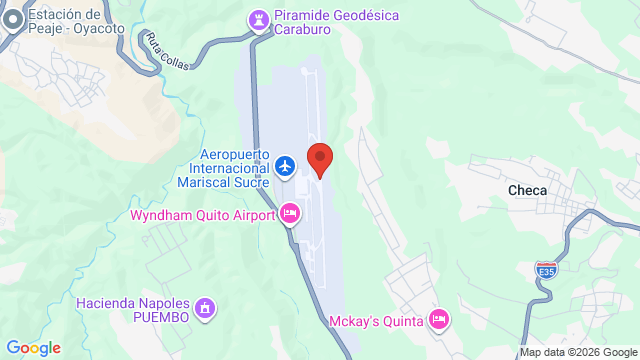
 Airlines and destinations
| Airline | Destinations |
|---|---|
 Avianca |
El Dorado (BOG) New York - JFK (JFK) Medellín - José María Córdova (MDE) Aeropuerto de Guayaquil (GYE) Aeropuerto de Cuenca (CUE) Aeropuerto de Manta - Eloy Alfaro (MEC) Showing 6 of 10 · Show more destinations |
 LATAM Cargo Chile |
Lima (LIM) Tocumen (PTY) Miami (MIA) Aeropuerto de Guayaquil (GYE) Aeropuerto de Campinas - Viracopos (VCP) Aeropuerto de Manaus (MAO) Showing 6 of 9 · Show more destinations |
 LATAM Airlines |
El Dorado (BOG) Lima (LIM) Miami (MIA) Aeropuerto de Guayaquil (GYE) Aeropuerto de Cuenca (CUE) Aeropuerto de Manta - Eloy Alfaro (MEC) Showing 6 of 8 · Show more destinations |
 Atlas Air |
El Dorado (BOG) Lima (LIM) Miami (MIA) Aeropuerto de Campinas - Viracopos (VCP) Aeropuerto de Manaus (MAO) São Paulo-Guarulhos (GRU) |
 Avianca Ecuador |
El Dorado (BOG) New York - JFK (JFK) Aeropuerto de Guayaquil (GYE) Aeropuerto de Cuenca (CUE) Aeropuerto de Manta - Eloy Alfaro (MEC) Aeropuerto de Baltra - Seymour (GPS) |
 Euroairlines |
Aeropuerto de Guayaquil (GYE) Adolfo Suárez Madrid-Barajas (MAD) Loja (LOH) Aeropuerto de Coca (OCC) Aeropuerto de Santa Rosa (ETR) Aeropuerto de Montería (MTR) |
Showing 6 of 34
 Nearby airports
-
Aeropuerto de Coca - Francisco de Orellana (OCC) 97.1 mi (156.2 km)
-
Aeropuerto de Manta - Eloy Alfaro (MEC) 170.3 mi (274.1 km)
-
Aeropuerto de Guayaquil - José Joaquín de Olmedo (GYE) 175.8 mi (282.9 km)